Newsroom
Newsroom
Did You Know? – RouteXL Has a New Multi-Visits Feature
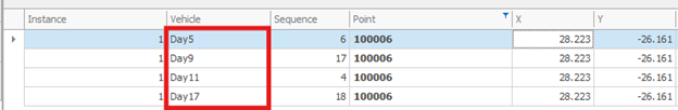
We have just added in a new feature in Quantitative Vehicle Routing tool of RouteXL that allows you to precisely stagger visits to points that need to be visited multiple times over a certain period. For example, you may want a point to be visited 4 times over a 4-week period, and you want each visit to be staggered into a different week. This is now possible! Example: Here are route results where we have point 10006 that needed to be visited 4 times, staggered into separate weeks.
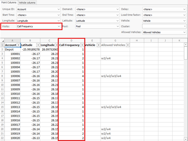
Example Input: In your input, you simply set your “Visits” field to the column specifying the frequency of visits to the point:
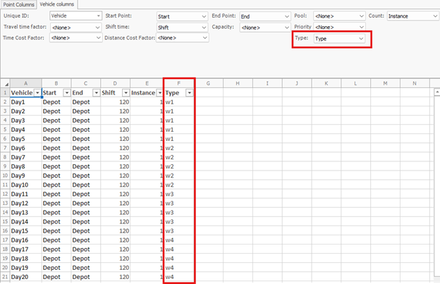
Then, in the Vehicles sheet, you have a vehicle representing each day. You then make a vehicle type representing each week using the Vehicles “Type” field:
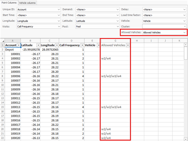
Finally, in the Points sheet you match up the vehicle types to each multi-visit point and enter in “w2/w4” etc. in the “Allowed Vehicles” field you set up:
Did You Know? – PrimeThought now has a new cloud-based licensing system
PrimeThought now has a new cloud-based licensing system available making single user licenses and floating licenses seamless!
You can easily switch between machines as long as you have the software installed.
Further, any crashes in the software due to errors will be reported straight to us for much faster handling!
When you upgrade your software, features are added to your license from our side and this will update automatically your side.
When you renew your license, you will not need a new license file to be sent to you, your license expiry date will update automatically your side.
You can still use the offline license file system but you now have the option to make use of our cloud licensing!
PrimeThought New Product Release ScheduleXL
The latest product release from PrimeThought is ScheduleXL. ScheduleXL uses the constraints calculated in DesignXL(our Mine Design package) or any third party package plus the actual design and parameters to produce a schedule based on vehicle and machine capacities.
ScheduleXL links bidirectionally with graphics to display and animate the schedule.
ScheduleXL can export schedules to Microsoft Project as needed and has its own Gantt chart facility with hot graphics link.
Did You Know? | Mini Maps
In all our spatial products you can turn on the MiniMap window to get a birds eye view of your design or map and then easily zoom and pan to different areas straight from there. Simply turn it on in the View tab. Use left mouse click on area to pan to it and mouse wheel to zoom in and out
Did You Know? | LocateXL is an add-in to SpatialXL
LocateXL is an add-in to SpatialXL which is an open extensible Geocoder that works within Microsoft Excel or as a standalone application if you need to process hundreds of thousands or even a million records at a time.
Did You Know? | Bookmarks
In all our spatial products you can create and save bookmarks for locations on your map. You can then easily move to these locations with the click of a button.
Did You Know? | Geoscope Files
In SpatialXL and SpatialStudio(The standalone version of SpatialXL),there is a feature available that can be purchased that gives you the ability to publish read-only map files (called Geoscope files) with all data layers and themes etc. set up in SpatialXL, that another can open and use without having to have SpatialXL installed on their computer. These files can be distributed freely and protected with passwords, locked to machines and even have expiry dates set on them. They provide a live interactive file that can have layers etc. ticked on and off and data that can be drilled down into.
The datasets we provide with our software!
Neighbourhood Lifestyle Index
The GEOTERRAIMAGE Neighbourhood Lifestyle Index (NLI) data product is an income based segmented classification that classifies neighbourhoods according to their income and various lifestyle characteristics.
It is the only income-based segmentation dataset available at Enumeration Area level in South Africa. Other characteristics such as diversity in terms of income, race, age, and gender are also profiled.
The following highlighted characteristics provides insight into the uniqueness of this dataset:
The NLI is the only income-based segmentation dataset available at an Enumeration Level (EA) in South Africa. The NLI is not only modelled on income but also utilises other variables to provide a unique set of indexes. Segmentations and data modelling are done under the supervision of Dr Ariane Neethling (Professional Statistician). The most recent release is dated 2022 The income clusters are provided as index values in a range from 1-10 (where 1 indicates the lowest income and 10 indicates the highest income) The index values are vulnerable to land use change.
Demographics
The GEOTERRAIMAGE Demographic data product is available for the whole of South Africa, any of the nine provinces or at a more granular level down to an EA level. This information is essential to private and public sectors such as planners, researchers, economists, retailers, media and advertising, healthcare, government officials (municipal to national), non-profit or aid organisations etc. to ensure sustainable development and planning. This dataset provides up-to-date insight into the current demographic distribution per EA in terms of
Number of households Gender Race Age group As well as the dominant group in each of these categories. The following highlighted characteristics provides insight into the uniqueness of this dataset:
Includes up-to-date Demographic information for South Africa at EA level. Demographic data modelled at building level under supervision of Dr Ariane Neethling (Professional Statistician). The most recent release is dated 2022. The dataset is benchmarked to the latest estimates form STATS SA at district level.
Advanced Population
Advanced Population (including Working Population) Dataset:
The GEOTERRAIMAGE Advanced Population data product is available for the whole of South Africa, any of the nine provinces or at a more granular level, down to an EA (Enumeration Area) level.
The GEOTERRAIMAGE Advanced Population dataset not only includes annually updated information of the population (night time population), but also a modelled estimated population distribution of the population during the day, making it unique and the only dataset of its kind. An estimate of the number of workers and non-workers, that could be found within any study area during daytime working hours allow users to understand different area characteristics in more detail.
This dataset is unparalleled in South Africa as it is based on proprietary GEOTERRAIMAGE information on both individual formal & informal residential data, as well as 3-Dimensional non-residential building datasets.
The following highlighted characteristics provides insight into the uniqueness of this dataset:
Includes up-to-date modelled working population for South Africa at EA level. Includes day time retained population for South Africa at EA level. Population modelled at building level, under supervision of Dr Ariane Neethling (Professional Statistician). The most recent release dated 2022. The latest STATS SA employment status and employment sector data (Q4 2022) is used as a benchmark for the data at metro and non-metro level. Any identified data anomalies are flagged in the dataset.
Building Based Land Use Data Set
The Building Based Land Use data product provides full national coverage of South Africa and is the only dataset of its kind. Using the most recent satellite images, we aim to strategically and continuously identify, map and classify every single building in South Africa. Our unique 84-class classification describes the land use type of every building at a micro level, providing primary, secondary and tertiary information per building essential to successful urban and regional planning. Data is summarized and supplied at EA level.
The following highlighted characteristics provides insight into the uniqueness of this dataset:
The only dataset which includes information on all building structures across South Africa, at a micro level With more than 16 Million building structures mapped across South Africa, this dataset provides a holistic national view of all building structures The full dataset contains 84 classes and allows for a primary, secondary and tertiary land use per building or cadastre parcel, information essential to successful urban and regional planning. Our new developments dataset provides the cutting-edge factor, as new developments are tracked monthly to form the basis of the update process. Accuracy statements are included.
The most recent release is dated 2022
New developments dataset
The GEOTERRAIMAGE New Developments dataset provides insight, on a national scale, to where current earth works and expansions are taking place, a vital component of successful planning. With access to satellite imagery we are able to report monthly on changes such as new construction sites (significant earth works), the development of new residential areas and also detect change such as larger buildings or construction sites (new commercial or industrial buildings for example), farm land (cultivation) changing to construction sites or even environmental changes. Inner-city construction projects are also identified and classified.
This allows us to identify new developments at regular intervals to identify changes as they happen.
These occurrences are classified according to the GEOTERRAIMAGE Building Based Land Use 84 class classification system. Consistent monthly updates aid in answering not only where, but also what, how much and what the impact will be.
With our New Developments dataset, GEOTERRAIMAGE offers insights to understanding where new housing, commercial or industrial sites are being erected right across South Africa, allowing industries to plan ahead and ensure that future service delivery demands will be met, as areas expand or develop.
The following highlighted characteristics provides insight into the uniqueness of this dataset:
The New Developments dataset is the only National dataset available identifying and classifying earth works and expansions. Monthly updates provide consistent information on the ever-changing South African environment. This dataset is highly accurate and reliable due to information captured at micro level (individual building structures). The 84-class classification system provides information on Residential, Commercial and Industrial developing areas across South Africa. The most recent release is dated 2022
Solar panel installations
This dataset is the current installations of solar panels as well as predicted capacity