![]()
The map navigation tools allow you to pan and zoom around your map. The easiest way to navigate is to use the Pan Tool ![]() and your mouse scroll wheel. Click the ‘Pan’ button
and your mouse scroll wheel. Click the ‘Pan’ button ![]() and click and drag your mouse cursor on your map to move around. To zoom in and out, use your mouse scroll wheel.
and click and drag your mouse cursor on your map to move around. To zoom in and out, use your mouse scroll wheel.
You can also zoom in and out using the ‘Zoom’ buttons ![]() Draw a square over the area you want to zoom in or out to, or click with the left mouse button on your map to zoom in or out incrementally.
Draw a square over the area you want to zoom in or out to, or click with the left mouse button on your map to zoom in or out incrementally.
The two ‘Zoom Fit’ buttons (globes) allow you to zoom to the extent of your data ![]()
1.The first globe will zoom to the extent of all your map layers
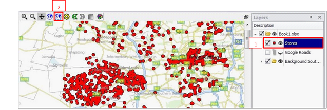
2.The second globe will zoom to the extent of one map layer only - the one you have clicked
o(highlighted) in your layer description box
oClick the layer in the Layer Description box to highlight it in Blue (1)
oClick the ‘Zoom fit layer’ button (second globe) (2)
oThe map will zoom to the extent of that layer
oHint, you can also right click a layer in your Layers Description Box and click ‘Zoom fit’ to zoom to that layer
To zoom back to or from your previous viewing extents at any time, click the ‘Arrow’ buttons
![]()