| 1.4. | Set Distance Check (*optional) |
The distance check enables you to check the distance from a point in the suburb/town address data to a point in the suburb/town geocode results.
This is a useful check for results where the geocode suburb/town does not match the suburb/town in your street address data e.g. Street address is 23 Katherine Street Sandhurst, and geocode address is 23 Katherine Street Sandton. Just because the names do not match does not always mean that the geocode results are incorrect. For example, the street address may be situated in the adjoining suburb, the suburb name may actually be a town name (as with the Sandton example above), the name of the suburb may be spelled slightly differently e.g. Sundhurst instead of Sandhurst, or you could have suburb extensions like Sandhurst east etc.
To set the distance check:
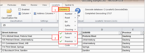
•Click the ‘Columns’ Button (1)
•Select the Suburb and/or Town and Province columns (2) i.e. for suburb, make sure you choose your column(s) that contain suburb data, and the same for towns and provinces. If you do not have data for one of the columns e.g. Towns, you can just leave it out.
The distance check geocode result will display the distance in meters from a point in the suburb/town address to a point in the suburb/town provided in the geocode results, to enable a direct distance comparison
