Since points often need to be located in mining, and in our case its locations of sections we are now going to cover how points are located in mining in general.
This will then apply to locating sample sections in the case of sampling.
On the surface, like in open-pit mining, because there is a clear view of the sky an ordinary GPS (Global Positioning Unit) can be used to get the location of a sample section.
In underground mining this is not the case, so another method was developed.
It all works of the idea of measuring or as they call it surveying new points from existing known points.
Known points in mining are referred to as ‘Pegs’, because they are usually marked by a small peg that is knocked into the rock in the ceiling of the workings. (It is placed in the ceiling because it will not get damaged or moved there.)
So, in general to find the location of a point we look for the nearest peg or pegs and then take measurements from the peg to then work out the new location.
This is often done using tape measures, or tapes for short.
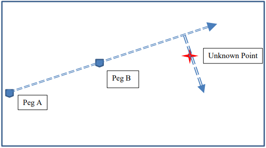
One typically finds two nearest pegs to a point and then puts a tape measure between and along the pegs:

And then another at right angles to the first tape. Then taking measurements along the tapes one can work out the unknown point from the two know peg points.
So in the above case we needed two tape measures to work out the location of the unknown point.
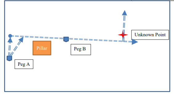
Sometimes however it is not possible to draw a tape straight across the two pegs as shown above, because of an intervening pillar. In this case one uses extra tapes called ‘Ties’ as follows:

The two extra tapes coming from peg A are referred to as ties.
Note that in more complicated scenarios we could even have ties coming from peg B. In any case using the measurements along the various tapes we can get the location of the unknown point.
So using pegs, tapes and even tie tapes we can get the location of sample sections.